The Local Nature Recovery Strategy for Derbyshire
Local Nature Recovery Strategy
The Derbyshire Local Nature Recovery Strategy is available to download here, and the appendices can be found on the Resources page.
Resources pageDerbyshire’s Local Nature Recovery Strategy is now live!
We are pleased to announce that the Derbyshire Local Nature Recovery Strategy (LNRS) is now live!
The LNRS sets out a vision for restoring and enhancing nature across the county. The strategy was developed with the collaboration and support of a large number of partners and stakeholders including environmental organisations, local authorities, farmers and landowners, communities and members of the public, and sets out priorities and opportunities to help nature thrive in Derbyshire. It supports national ambitions for nature recovery while reflecting the unique landscapes, habitats and challenges and opportunities in our county.
What’s included
The published Local Nature Recovery Strategy includes:
- Thriving with Nature – the LNRS for Derbyshire – the main strategy document (also known as the Statement of Biodiversity Priorities) detailing the background and approach to preparing the strategy, the description of the strategy area and opportunities for nature recovery, and setting out our Priorities and Measures (actions)
- A ‘Non-technical guide’ document (coming soon) – a shorter document that summarises the Local Nature Recovery Strategy, to help you find the information you need, more quickly
- The Local Habitat Map – Interactive mapping showing the locations in which key Measures (actions, particularly for habitat creation, management and enhancement) should be focused to have the greatest benefits for nature. The mapping also shows areas that are currently of particular importance for nature and biodiversity, and the areas that could become important in the future.
- Appendices – which provide detailed information on how the strategy was developed, including information about the consultation and engagement work undertaken throughout the development of the strategy.
The Local Habitat Map
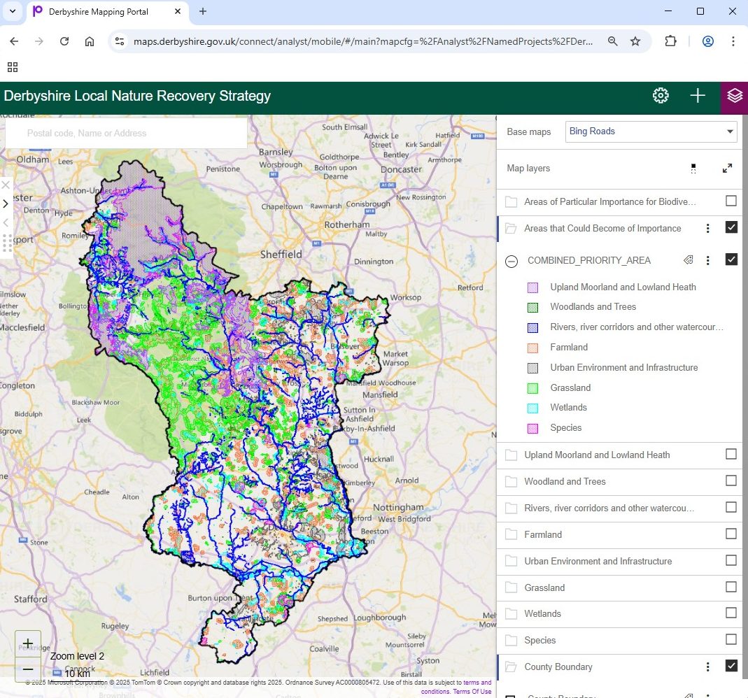
One of the most important aspects of the LNRS is the mapping of areas that could become of importance for biodiversity. You can access our interactive mapping and view the priority areas here.
Derbyshire LNRS interactive mappingWhat does the Local Habitat Map show
The Local Habitat Map for Derbyshire is divided into three key components:
1. Existing Areas of Particular Importance for Biodiversity (APIB)
This mapping shows those areas that are already recognised for their importance for biodiversity. It includes designated sites such as Sites of Special Scientific Interest (SSSI), National Nature Reserves (NNR), Local Nature Reserves (LNR), and Local Wildlife Sites (LWS), and areas of irreplaceable habitat.
2. Areas that Could Become of particular importance (ACB)
The purpose of an LNRS is to identify locations that would provide the greatest benefit for nature and the wider environment through targeted actions for habitat recovery and investment. We do this by mapping areas which we believe ‘could become of particular importance for biodiversity’ or ‘where the recovery or enhancement of biodiversity could make a particular contribution to other environmental benefits’. These areas are collectively referred to as ‘areas that could become of particular importance’.
3. Mapped Measures
To map these areas, the Measures that have the potential to make the greatest contribution to our Strategy’s priorities, and to nature recovery, have been identified. These measures typically focus on delivery ‘on the ground’ – particularly the safeguarding, restoration or enhancement of existing habitats, and the creation of new habitats. Those measures selected for inclusion on our Local Habitat Map are known as ‘mapped measures’ and the mapping shows the locations that have the greatest potential to deliver against a particular measure. However, these are not the only places where those measures could be implemented – simply the locations likely to deliver the greatest benefits.
How to use the mapping portal
Instructions on how to use the mapping portal are shown on the image below:
